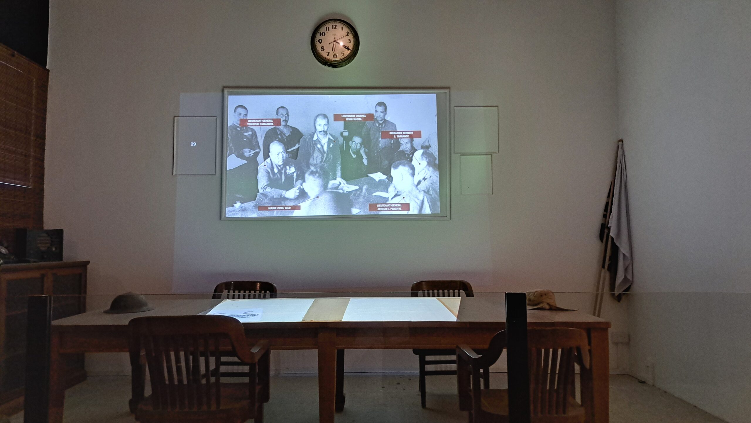
The Former Ford Factory is now a museum about Singapore during WWII. Built in 1941 as a state of the art facility, it was the first Ford production plant in SE Asia after 15 years building cars in garages. In this very building the British surrendered to the Japanese on February 13, 1942, the office they used left as it was.
The Brits should have invested more in the defense of Singapore during the 1920’s and 30’s, but given the distances and territory involved it simply did not have enough soldiers and equipment. It’s not that they did not try. In the early 1920’s the British began constructing a naval base, finishing in 1939. However it was too small, only able to support about 20% of the British fleet. The plan was for Singapore to hold out until the rest of the fleet arrived. The Japanese capture of Singapore took about 60 days. The British fleet still had not arrived.
Japan began bombing Singapore on December 8, 1941, hitting Chinatown and Raffles Place. They landed in Malaysia at the same time. After the 1937 Japanese attack on China many Singaporeans joined the Singapore Volunteers Corps and the Royal Navy Volunteer Reserve, others the Civilian Defense Corps and the Medical Auxiliary Services. Some helped build air raid shelters. These efforts, like the British naval base, were of little use.
The experienced soldiers of the 5th and 18th divisions of the Japanese armies led the ground assault. Within a day they destroyed or damaged more than half of British largely obsolete aircraft and captured airfields in Malaysia. They belatedly formed eight civilian battalions of 150 people each to build defensive fortifications and others, with just ten days of training, were assigned to defend Jurong Road. Fighting in Singapore itself, which began in early February, 1942, lasted less than a week.

British Surrender
On 13 February 1942, Japan captured the Ford factory. On 15 February 1942, Lieutenant-General A. E. Percival unconditionally surrendered in the boardroom, determining the fate of Singapore for the next three and a half years. https://corporate.nas.gov.sg/former-ford-factory/overview/.


Japanese Rule
There were some 100,000 POW’s and several thousand European citizens at the time of the Japanese takeover. About 3000 were marched to Changi Prison and the nearby barracks, designed to hold 800. Civilians passed them food and money along the way, despite the risks. Once imprisoned they were always hungry, yet made to clear war damage, bury corpses and build memorials to Japanese dead.
The Japanese massacred thousands of Chinese in February and March of 1942. There were other random acts of violence and intimidation. By 1943 the violence had abated, but there were still arbitrary arrests and torture. Food, fuel and medicine were in short supply in a city of one million with few natural resources. Many survived on what they were able to grow. Starting in September, 1942 many were sent to work on the Siam-Burma Railway. Huge numbers died under the horrific working conditions. Approximately 17,000 were housed in barracks designed for 800.
Japan’s government renamed Singapore to Syonan-to (Light of the the South), changed the clocks to Japanese time and the calendar to their own. They took over the businesses of all Western companies and some Chinese as well. Businesses were made to produce goods for the Japanese war effort. There was strict rationing and movement was restricted. There was high official unemployment but there were illegal jobs, black markets and a large number of off the books street vendors.
To reduce overcrowding the Japanese opened farmland, hoping to relocate 300,000 Singapore in Endau, Johor, Malaysia. Some 12,000 Chinese were the first to be sent, successfully establishing farms. The second effort was not successful as the land was not suited for farming, while thousands died from malaria. The effort ceased after that.
In resistance, Malaysia Communist Chinese formed the Malayan People’s Anti-Japanese Army. Those aligned with the Kuomintang joined Force 136. Allied forces engaged in sabotage, sinking seven Japanese vessels in the Singapore harbor. There were 11 US air raids, ending in March, 1945.
Post War Singapore
The Japanese forces of Singapore and Jahore surrendered aboard HMS Sussex. The British returned in September, 1945, welcomed by the locals. There was much need for welfare and relief. The Allied Land Forces – South East Asia tried only 131 men for war crimes. Only two were sentenced to death. The Singapore Chinese Appeal Committee unsuccessfully asked for additional death penalties.
On April 1, 1946 civilian administration resumed as a Crown Colony. As in Brittan, the government became involved in education, housing, health and social welfare. While the British introduced self-government in Malaysia it did not do so in Singapore. Communist insurrections in China, Malay, Burma, Indochina and the Philippines were a major concern, with Singapore serving as a base for defending against Communist expansion. Malaysia became firmly anti-communist in the 1950’s. As a result Singapore became part of Malaysia on 16 September 1963 following a merger with Malaya, North Borneo, and Sarawak.
Singapore became an independent republic on 9 August 1965 after its expulsion from Malaysia. It has evolved into not only a major port with its modern facilities but also a major finance center after a difficult period following independence.